A compliance roadmap for foreign investors
Foreign investment in Indonesian land is governed by national agrarian law, zoning regulation, and spatial planning enforcement. While foreigners are prohibited from owning land outright, they may acquire lawful access rights and development use under specific structures.
This article outlines the complete legal, spatial, and procedural steps required to legally invest in land in Bali, including to secure, develop, and operate land for residential, commercial, institutional, or environmental purposes. It provides a step-by-step roadmap from informal exploration through due diligence, structuring, building approval, licensing, and risk management.
Each section is grounded in current regulatory standards, spatial law, and the field realities of acquisition and enforcement, especially within Bali, where banjar, adat authorities, and local enforcement influence outcomes as much as formal documents.
The sections are structured as follows:
- Site identification and access authorisation
- Legal and spatial due diligence
- Legal structuring of land use rights
- Planning and building approval
- Licensing and tax registration
- Risk identification and regulatory enforcement
- TraceWorthy legal support and field coordination
1: Identifying and Securing a Viable Site
Every land acquisition begins with identifying a site that appears suitable for the intended use. Before legal access or zoning can be confirmed, early engagement must be structured to allow legal review without premature commitment.
Identify Potential Land
- The process begins by identifying a location that appears suitable for the investor’s intended use and ability to legally invest in land in Bali. The intended use may range from private occupation to regulated enterprise, and must be confirmed as permissible under the spatial and legal frameworks that govern the site.
- This often occurs through informal referrals, on-site visits, or initial outreach by agents or landholders.
- At this stage, the investor must confirm broad compatibility (such as proximity, access visibility, land shape) but does not yet have access to zoning or title data.
Discuss Basic Deal Terms
- Once interest is confirmed, TraceWorthy, or the nominated sales representative, facilitates a discussion of price, intended use, and term of lease (if applicable).
- If both parties show alignment, this leads to the next step: structuring a conditional offer that enables legal investigation.
Submit Conditional Offer with Access Authorisation
- TraceWorthy prepares a conditional offer letter with clauses that:
- Confirm the offer is subject to full legal due diligence
- Grant TraceWorthy power of attorney (surat kuasa) to access title, zoning, and site data
- Allow cancellation where spatial use, title, or legal structure are found to be non-compliant
This step enables formal zoning, title, and infrastructure review without prematurely binding either party.
2: Comprehensive Land Due Diligence and Structuring Land Access
Before any access structure or agreement can be considered, TraceWorthy undertakes a full legal, spatial, and infrastructure review of the land. This phase involves coordinating multiple professionals under landholder-authorised power to ensure that what appears viable is in fact legal and structurally sound. Once complete, the legal structure for land access is matched to the investor’s capacity and intended use.
Complete Comprehensive Due Diligence
TraceWorthy conducts a full legal, spatial, and physical review before any land access structure is confirmed. This includes review of both privately held land and areas affected by public control or community-based governance.
TraceWorthy conducts a full legal, spatial, and physical review before any land access structure is confirmed. This includes review of private and public land classification, including state-controlled plots, beach corridors, maritime boundaries, and land held under Hak Pengelolaan (HPL). Where rights are granted under government management, derivative titles such as Hak Guna Bangunan (HGB) or Hak Pakai may be possible via formal application.
Legal and Ownership Verification
- Extracting and reviewing the land book (buku tanah) from BPN to trace ownership, mutation history, encumbrances, and restrictions.
- Verifying the legal structure of the landholder, including:
- Whether the title is held under SHM, HGB, or Hak Pakai
- Confirmation of the named grantor’s authority to lease or transfer use rights
- Corporate title validation through deed review and company registry confirmation (AHU)
- Family or multi-heir ownership requiring proof of succession and partition documentation
Survey and Site Condition Assessment
- Commissioning a licensed surveyor to:
- Re-measure and re-mark plot boundaries
- Provide topographic and contour maps for drainage, grading, and construction planning
- Conduct boundary conflict investigations if occupation does not match registered title
- Deliver measurement outputs required for PBG application and SLF inspection preparation
- Issuing a topographic overlay when required for slope, drainage, or infrastructure planning.
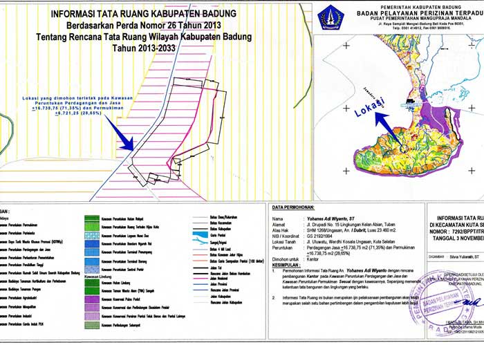
Spatial Compatibility and Zoning Compliance
- Reconciling ITR zoning with observed conditions, spatial plan boundaries (RDTR), and intended use.
- Reviewing provincial overlay maps such as Perda Provinsi and Peta Kegiatan Prioritas to identify tourism corridors, conservation zones, or regional development restrictions.
- Cross-referencing BPN data with satellite imagery and Google Earth overlays to identify spatial overlaps, buffer infringements, or greenbelt encroachment.
Access, Infrastructure, and Local Oversight
- Verifying legal access rights and confirming whether road entry is titled, granted, or informally used.
- Confirming infrastructure viability, including PLN (electricity) connection feasibility, PDAM (water) registration, and septic tank placement restrictions.
- Evaluating risks linked to community use, informal banjar access, or historical disputes.
TraceWorthy assesses where land, while legally titled, may fall under the influence of adat authorities including desa adat, banjar, or subak. In such cases, customary use, ritual claims, or seasonal access may affect the feasibility of infrastructure, licensing, or development. Where relevant, TraceWorthy engages local stakeholders to formalise acceptance and resolve potential conflicts.
All of these steps require landholder cooperation via a conditional offer and power of attorney.
Legal Reference: Law Number 26 of 2007 on Spatial Planning (as amended)¹
Legal Reference: Government Regulation Number 21 of 2021 on the Administration of Spatial Planning²
Legal Reference: Government Regulation Number 18 of 2021 on Management Rights, Land Rights, Apartment Units, and Land Registration³
3: Legal Structuring of Land Use Rights
Once due diligence confirms that the land, title, access, and zoning are compatible with lawful development or operational use, TraceWorthy determines the appropriate legal pathway to secure use rights and documents those rights in enforceable agreements.
TraceWorthy determines the appropriate legal pathway to secure use rights and documents those rights in enforceable agreements suitable for foreign land access in Indonesia.
Select the Legal Access Pathway
- For individual use: leasehold or Hak Pakai on state land (requires KITAS/KITAP).
- For business use: lease or HGB under PT PMA.
- Confirm that the landholder has lawful title and legal capacity to grant the relevant rights. Where the land is owned by an entity, verify corporate authority through deed review. For family or inherited land, confirm rightful heirs and identify whether partition or power of attorney is required.
Draft Fit-for-Purpose Agreements
- While notaries and agents may issue templates, TraceWorthy drafts fit-for-purpose agreements that reflect the zoning classification, land rights, and enforceability required for lawful operation.
- Include clear terms for access, use, and compliance with zoning and land rights.
- Ensure registration or deed conversion with a notary where required.
Verify Access and Infrastructure
- Site access, infrastructure, and utilities cannot be assessed independently of landholder involvement.
- TraceWorthy coordinates this review with the landholder after a conditional offer is accepted and access has been granted.
- Access roads must be legally granted and documented.
- Utilities (PLN, PDAM, drainage, septic) must be confirmed independently.
- Surveyors may be required to establish access feasibility.
4: Planning and Building Legally
Construction may only proceed once permitted zoning has been confirmed and building approvals have been granted under current regulations. A site with valid title is not sufficient. The process must be supported by a legally issued building construction approval (PBG) and, after construction, an SLF authorising lawful use of the building. A site with valid title does not automatically qualify for development approval. Once the building is complete, a post-construction inspection is required to obtain an SLF, without which the structure cannot be used legally or issued a commercial license.
Apply for PBG (Building Approval)
- PBG replaced the IMB in 2021, and must be obtained before construction.
- Submit architectural plans, ownership / lease documents, and zoning approval.
- Coordinate with Dinas PUPR and environmental agencies if required.
Legal Reference: Government Regulation Number 16 of 2021 on the Implementing Regulation of Law Number 28 of 2002 on Buildings⁶
Obtain SLF (Function Worthiness Certificate)
The Sertifikat Laik Fungsi (SLF) is a mandatory requirement for buildings to be legally occupied or used for their intended function. It confirms that the structure meets minimum safety, health, technical, and usability standards as per the approved PBG.
- SLF is required before any building can be legally occupied or used for its intended function. It applies to all new constructions, buildings undergoing major renovations or changes in function, and is a prerequisite for licensing, leasing, or sale.
- Cannot be issued without a valid PBG, unless the structure predates 2021.
- Application begins once construction is approximately 70% complete.
- Final SLF is issued only after post-construction inspection and confirmation of complete utilities, including electricity.
Legal Reference: Government Regulation Number 16 of 2021 on the Implementing Regulation of Law Number 28 of 2002 on Buildings⁶
5: Legalising Operations
A site may only be used for commercial operations once licensing, reporting, and taxation structures are in place in accordance with Indonesian law. TraceWorthy routinely encounters cases where landholders offer parcels under agricultural zoning while proposing that the investor operate a tourism, hospitality, or retail business. These offers are fundamentally misaligned with regulatory pathways.
A license cannot be issued for a business activity that conflicts with the RDTR or ITR classification of the land.
Business use of land requires registration of operational licenses, tax status, and statutory reports before regulated activity may begin. TraceWorthy structures compliance pathways that enable licensed commercial activity, whether the venture involves accommodation, tourism, or services. This includes sectoral licensing, tax and labour obligations, and ongoing investment reporting for PT PMAs.
Register for Licenses and Tax
- Register the NIB through OSS, then obtain the required risk-based business licensing outputs for each activity and each location, including Sertifikat Standar where the system requires it.
- Align KBLI selection to the trading activity using KBLI 2025, and keep an evidence trail that matches the selected activity lane and operating footprint.
- Register for tax (NPWP), BPJS, and comply with payroll, reporting, and local obligations that apply to the operating model.
File Investment Reports
- Submit LKPM investment activity reports through the applicable government reporting pathway for the company profile and project stage, using the current implementing regulation.
Legal Reference: Government Regulation Number 28 of 2025 on the Administration of Risk-Based Business Licensing⁸
Legal Reference: Minister of Investment and Downstreaming or Head of the Investment Coordinating Board Regulation Number 5 of 2025 on Guidelines and Procedures for the Administration of Risk-Based Business Licensing and Investment Facilities through the OSS System⁹
Legal Reference: BPS Regulation Number 7 of 2025 on the Indonesian Standard Industrial Classification (KBLI), including the six-month adjustment requirement¹⁰
6: Risks and Enforcement Exposure
Foreign investors often proceed on the assumption that documentation alone is sufficient to legalise land use. However, spatial, cultural, structural, and regulatory risks frequently emerge during due diligence, or after title has transferred, resulting in financial loss or enforcement action.
Spatial and Zoning Risks
- Land offered for tourism or business use that sits in greenbelt, cliff setback, or agricultural zoning
- RDTR or ITR designations that restrict the proposed activity
- Provincial overlays or regional plans that prohibit commercial permits
Legal Title and Ownership Risks
- Titles that have unclear succession, unregistered mutation, or overlapping claims
- Informal inheritance without partition agreement among heirs
- Undisclosed liens or encumbrances on the land
Access and Infrastructure Risks
- No legal or physical road access, or contested right of way
- Absence of PLN transformer or minimum electricity load
- Incompatibility with government-managed drainage corridors or setback from waterways
Community and Cultural Risks
- Land with shared or informal use by desa adat, banjar, or subak
- Ritual use or cultural restriction not visible in the title
- Refusal of local consensus, preventing development or licence issuance
Licensing and Operational Risk
- Attempting to apply for OSS-based licences with zoning that does not permit the business activity
- SLF rejected due to structural non-compliance or absence of supporting permits
- Tourism sector licensing outputs (including Sertifikat Standar where applicable) or spatial conformity approvals (KKPR or PKKPR where applicable) denied due to spatial non-conformity, buffer encroachment, or incomplete prerequisites
Enforcement Consequences
- Satpol PP demolition orders or stop-work notices
- Dinas PUPR rejection of PBG and SLF
- BKPM compliance warnings or blacklisting of PT PMA
- Police reports filed by neighbours, landholders, or adat bodies
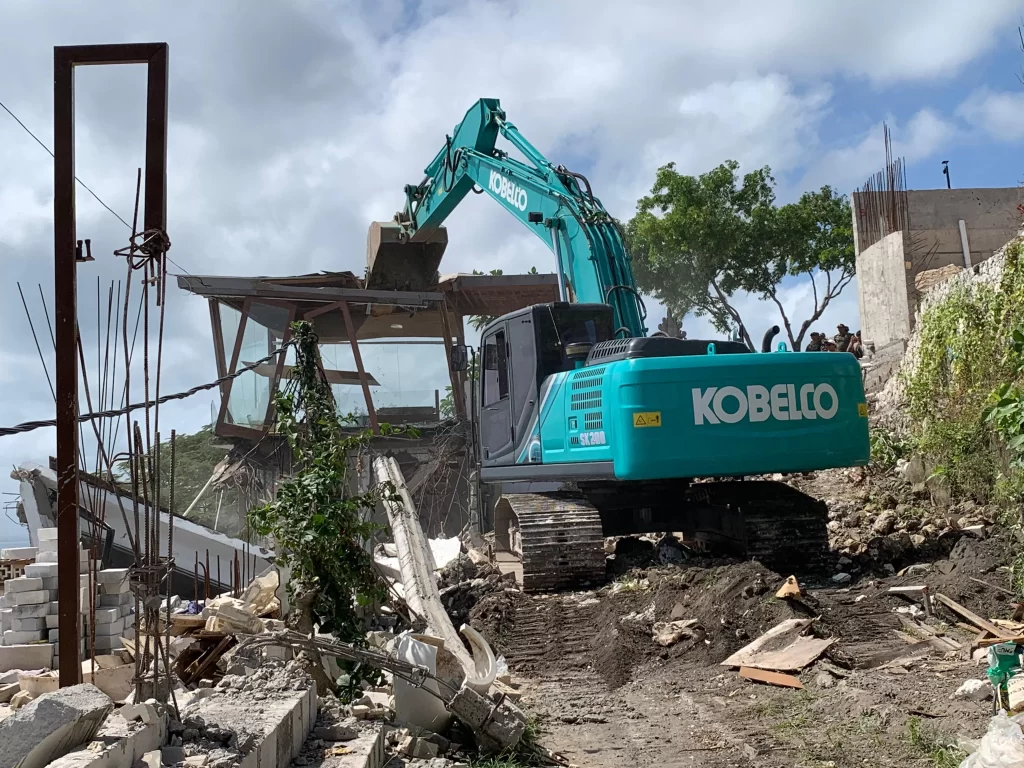
45 to 48 unauthorised structures demolished, including tourism and hospitality buildings.”
Real-World Enforcement Snapshot: Bingin Beach, July 2025
Over 300 residents affected; no compensation issued.
Operation led by ~500 personnel coordinating across agencies
TraceWorthy identifies these risks during pre-acquisition review, coordinates documentation and stakeholder dialogue to reduce exposure, and structures conditions for cancellation if compliance cannot be confirmed.
7: TraceWorthy’s Role in Providing Legal Support
TraceWorthy structures land access and compliance pathways based on zoning confirmation, title review, and authority mapping. We coordinate not only drafting, but also field access, data collection, and regulatory engagement.
TraceWorthy provides:
- Conditional offer design and power of attorney coordination
- Land and zoning audits
- Legal structuring and title analysis
- Notary-ready agreement drafting
- Permit and licensing coordination
- Full site access and infrastructure investigation
- Field-based surveying and topographic mapping (if required)
Schedule a consultation with our legal and compliance team. We will issue a structured review of your project, including zoning, title, land access, and permit pathways to legally invest in land in Bali.
All services are delivered in compliance with Indonesian national law and spatial regulations.
Bilingual Glossary
- AHU (Administrasi Hukum Umum) – Directorate General of General Legal Administration under the Ministry of Law and Human Rights, responsible for company and deed registration.
- Awig-awig – Traditional customary law used by Balinese desa adat to govern ceremonial obligations, land use restrictions, and social conduct.
- Banjar – Local community subdivision in Bali responsible for customary, social, and land-related decisions at the village level. Often holds informal influence over site access and development acceptance.
- BKPM (Badan Koordinasi Penanaman Modal) – Investment Coordinating Board
- BPN (Badan Pertanahan Nasional) – National Land Agency responsible for issuing, registering, and managing land rights and title records in Indonesia
- BPJS (Badan Penyelenggara Jaminan Sosial) – Social Security Administering Body
- Desa Adat – Customary village authority in Bali, operating parallel to formal government structure. Governs spiritual, ceremonial, and land-use practices based on traditional law (awig-awig).
- Dinas PUPR (Dinas Pekerjaan Umum dan Penataan Ruang) – Regional office of Public Works and Spatial Planning responsible for issuing building approvals (PBG) and overseeing infrastructure planning and compliance.
- HGB (Hak Guna Bangunan) – Right to Build
- Hak Pakai – Right of Use
- ITR (Informasi Tata Ruang) – Spatial Use Information
- KBLI (Klasifikasi Baku Lapangan Usaha Indonesia) – Indonesian Standard Business Classification
- LKPM (Laporan Kegiatan Penanaman Modal) – Investment Activity Report
- NPWP (Nomor Pokok Wajib Pajak) – Tax Identification Number
- OSS (Online Single Submission) – Centralised Business Licensing Platform
- PBG (Persetujuan Bangunan Gedung) – Building Approval
- PDAM (Perusahaan Daerah Air Minum) – Regional water utility company responsible for piped water infrastructure and supply licensing.
- Perda Provinsi – Regional regulation issued at the provincial level to govern zoning, spatial development, and land use corridors.
- Peta Kegiatan Prioritas – Priority Development Map. A spatial tool used to identify zones of targeted investment, tourism, or conservation under regional planning
- PLN (Perusahaan Listrik Negara) – Indonesian state electricity company that manages power distribution and infrastructure access.
- PT PMA (Penanaman Modal Asing) – Limited liability company incorporated in Indonesia with foreign shareholding, registered with the Investment Coordinating Board (BKPM)
- RDTR (Rencana Detail Tata Ruang) – Detailed Spatial Plan
- SHM (Sertifikat Hak Milik) – Freehold Title
- SLF (Sertifikat Laik Fungsi) – Function Feasibility Certificate
- Subak – Traditional Balinese water management and rice irrigation cooperative. Often holds cultural and seasonal usage rights to agricultural land, particularly in rural zones.
- Surat Kuasa – Power of attorney. A formal letter authorising a third party to act on behalf of the landholder for legal and administrative purposes.
- TDUP (Tanda Daftar Usaha Pariwisata) – Tourism Business Registration
- Satpol PP (Satuan Polisi Pamong Praja) – Civil service police unit responsible for enforcing regional regulations, including demolition orders and land use enforcement.
- SIPR (Surat Izin Pemanfaatan Ruang) – Spatial Use Permit required for certain business or development activities in regulated zones.
Legal References
¹ Law Number 26 of 2007 concerning Spatial Planning (Undang-Undang Nomor 26 Tahun 2007 tentang Penataan Ruang)
Official source: https://peraturan.go.id/id/uu-no-26-tahun-2007
³ Basic Agrarian Law Number 5 of 1960 (Undang-Undang Nomor 5 Tahun 1960 tentang Peraturan Dasar Pokok-pokok Agraria)
Official source: https://peraturan.go.id/id/uu-no-5-tahun-1960
⁴ Government Regulation Number 18 of 2021 concerning Management Rights, Land Rights, Apartment Units, and Land Registration (Peraturan Pemerintah Nomor 18 Tahun 2021 tentang Hak Pengelolaan, Hak Atas Tanah, Satuan Rumah Susun, dan Pendaftaran Tanah)
Official source: https://peraturan.go.id/id/pp-no-18-tahun-2021
⁵ Government Regulation Number 21 of 2021 concerning the Administration of Spatial Planning (Peraturan Pemerintah Nomor 21 Tahun 2021 tentang Penyelenggaraan Penataan Ruang)
Official source: https://peraturan.go.id/id/pp-no-21-tahun-2021
⁶ Government Regulation Number 16 of 2021 concerning the Implementing Regulation of Law Number 28 of 2002 concerning Buildings (Peraturan Pemerintah Nomor 16 Tahun 2021 tentang Peraturan Pelaksanaan Undang-Undang Nomor 28 Tahun 2002 tentang Bangunan Gedung)
Official source: https://peraturan.go.id/id/pp-no-16-tahun-2021
⁷ Article 275, Government Regulation Number 16 of 2021 (Pasal 275, Peraturan Pemerintah Nomor 16 Tahun 2021)
Official source: https://peraturan.go.id/id/pp-no-16-tahun-2021
⁸ Government Regulation Number 28 of 2025 concerning the Administration of Risk-Based Business Licensing (Peraturan Pemerintah Nomor 28 Tahun 2025 tentang Penyelenggaraan Perizinan Berusaha Berbasis Risiko)
Official source: https://peraturan.go.id/id/pp-no-28-tahun-2025
⁹ Minister of Investment and Downstreaming/Head of the Investment Coordinating Board Regulation Number 5 of 2025 concerning Guidelines and Procedures for the Administration of Risk-Based Business Licensing and Investment Facilities through the Online Single Submission System (Peraturan Menteri Investasi dan Hilirisasi/Kepala BKPM Nomor 5 Tahun 2025 tentang Pedoman dan Tata Cara Penyelenggaraan Perizinan Berusaha Berbasis Risiko dan Fasilitas Penanaman Modal Melalui Sistem Perizinan Berusaha Terintegrasi Secara Elektronik (Online Single Submission))
Official source: https://jdih.bkpm.go.id/document/peraturan-menteri-investasi-dan-hilirisasikepala-badan-koordinasi-penanaman-modal-nomor-5-tahun-2025-tentang-pedoman-dan-tata-cara-penyelenggaraan-perizinan-berusaha-berbasis-risiko-dan-fas
¹⁰ BPS Regulation Number 7 of 2025 concerning the Indonesian Standard Industrial Classification (KBLI) (Peraturan Badan Pusat Statistik Nomor 7 Tahun 2025 tentang Klasifikasi Baku Lapangan Usaha Indonesia)
Official source: https://peraturan.go.id/id/peraturan-bps-no-7-tahun-2025